


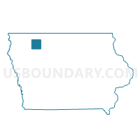
EVERLY Voting District, Clay County, Iowa
About
Outline

Summary
| Unique Area Identifier | 581796 |
| Name | EVERLY Voting District |
| County | Clay County |
| State | Iowa |
| Area (square miles) | 1.10 |
| Land Area (square miles) | 1.09 |
| Water Area (square miles) | 0.02 |
| % of Land Area | 98.51 |
| % of Water Area | 1.49 |
| Latitude of the Internal Point | 43.16513040 |
| Longtitude of the Internal Point | -95.31753320 |
Maps


Graphs
Select a template below for downloading or customizing gragh for EVERLY Voting District, Clay County, Iowa


Neighbors
Neighoring Voting District (by Name) Neighboring Voting District on the Map
- LONE TREE TWP W/O EVERLY Voting District, Clay County, IA
- WATERFORD TWP Voting District, Clay County, IA